The Natural Wonder of Amazon
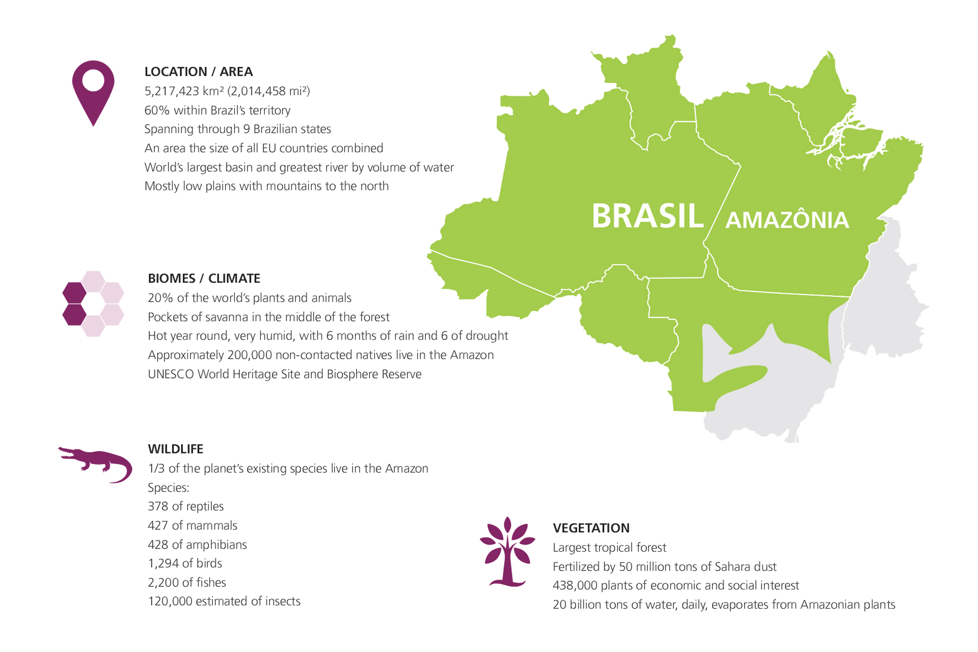
The Amazon Rainforest is the largest equatorial forest on the planet. It occupies a total of 5,217,420 km2 (2,014,458 mi2) and covers 40% of the Brazilian territory, extending through Bolivia, Peru, Ecuador, Colombia, Venezuela, Suriname, Guyana and French Guiana.
The Amazon Basin is the largest in the world, with almost 4 million km2. It is formed by broad rivers of muddy water, black and clear waters. Known to have the largest biodiversity in the world, the forest is basically formed by dry land woods, that do not suffer from river floods; floodplain forests, that flood in flood season and igapó forests that are almost flooded all year. There are also some parts of cerrado within the forest, as well as poor vegetation and grazing over sand spots.
In the dryland forests, most of their trees are large. They form a cover that makes it difficult for the sun to penetrate and makes the ground dark and damp. The falling leaves, microorganisms, rains, they are all interconnected in the forest and are part of a complex recycling process that ensures the maintenance of the ecosystem.
The clear water rivers such as the Xingu, Tapajós and Trombetas, have their sources in the highlands of Brazil and the Guianas. The middle and high points of these rivers have many rapids currents and waterfalls. As they drain huge and very eroded areas, their waters are relatively transparent and alkaline.
Blackwater rivers are formed on sandy soils in the Central Amazon. They have Ph between 3 and 5, given the amount of acids resulting from decomposition of plant organic matter, which covers the forest soil and is carried by floods. The Negro River, the largest affluent on the left bank of the Amazon River, is the longest blackwater river in the world.
It is navigable 720 km above and its mouth can only be 1m deep in dry weather.
CLIMATE AND VEGETATION
Known for containing the greatest biodiversity in the world, the Amazonian Forest is basically made up of 3 situations: rainforest on the mainland, rainforest in floodplains known as várzea bushes and rainforest in permanently flooded areas, known as igapós. The vegetation on the mainland does not suffer with the floodwaters of the river. The flood forest is flooded in the season of the floods, and the flooded jungle always remains that way for almost the whole year.
Within the jungle there are also enclosed areas, with vegetation and poorer pastures in sandy spots.
The dry land jungle has an extremely nutrient-poor soil. Plant roots, by symbiosis with some types of fungi, are able to rapidly decompose the organic matter deposited in the soil in order to absorb nutrients.
In the flooded river jungle we find plants with respiratory roots and pores that allow the absorption of oxygen from the atmosphere. Areas located in lowlands and subject to periodic flooding by white or cloudy waters, from rivers of regions rich in organic matter, make up the Várzea jungle.
The areas flooded by black water, which run on sandy and mineral-poor lands, and that acquire a dark coloration due to the organic matter present, are the so-called igapó jungle. The falling leaves, the micro organisms, the rains; everything is interrelated in the jungle and is part of a complex recycling system, which guarantees the maintenance of the ecosystem.
The climate in the region is extremely humid, with a medium temperature between 25 to 27 degrees Celcius and the maximum is 40 degrees.
Rainfall is between 2000/3000 mm per year. During the rainy months, the width of the rivers, which in the dry season is between 1.6 and 10 km, reaches the incredible 48 km mark. The speed of the current goes from 2.4 to 8 km / hour. Some rivers have their levels increased by 15 meters in relation to the drought period.
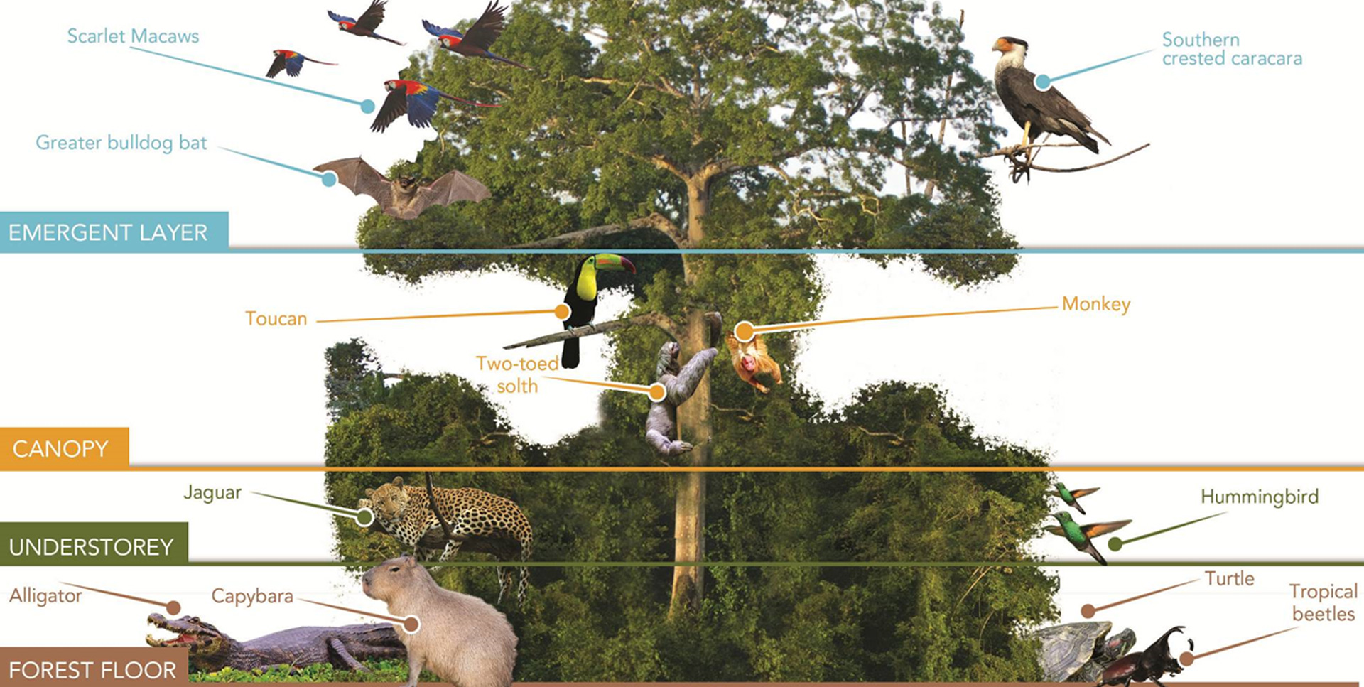
Tropical forests are made up of vegetation that grows at different rates, heights, and densities. Divided into layers or floors, each part concentrates a unique environment:
• The emergent layer receives the most sunlight, rain, and winds. Trees like the “Brazil nut” and samaumas grow to 70 m (230 ft) and dominate this layer, casting shade on the trees below, but are so tall that the light still passes through. Some larger monkeys reach this layer, but most of life is winged animals such as large raptors, macaws, and bats.
• The canopy layer still receives a lot of sunlight and rain, but it is so dense that, below this point, it is a gloomy world. The vines climb up the trunks and create a blanket from tree to tree. Bromeliads are attached to the highest branches. These trees are rich in fruits and nuts, which explains why it is the layer with the most wildlife.
• The understory layer grows on patches of sunlight and rain that drip from the canopy. These plants provide food and shelter for small animals and birds. Jaguars climb this layer to escape the rising water, and in some areas of the Amazon, they can live for 4 months in these branches.
•The forest floor hardly receives any light. Wherever there is an opening in the upper layers, shrubs and sprouts begin to grow. The combination of heat, darkness and moisture with dead leaves covering the floor is the ideal setting for fungi to flourish. Insects abound. Rodents and animal-eating insects such as anteaters find plenty to eat.
CLIMATE
Average Temperature: 27°C (80°F)
Rainy season: from December to July
Dry season: AAugust to November, October and November being the driest months.
Best time to visit: all year round, just the landscape and what we can see changes.
You will hear a lot: rainy season and dry season. This is how they divide the seasons in this region, and the difference between them can completely change the landscape. June and July are the months when the water level is highest due to the amount of rain. During these months, you can navigate the flooded forests in canoes and you have the privilege to see and appreciate the beauty of treetops and animals such as sloths, monkeys and birds.
In addition, many plants are filled with fruit and flowers, which attracts birds and primates at the water's edge so we can get a better look. During the dry season, the levels of most rivers in the central Amazon begin to fall, making river beaches visible.
October is the driest month, but not the warmest. The hottest is June (about 34 ° C), which is the opposite of other states in Brazil that are experiencing winter in the middle of the year. October is the coldest month (around 22 ° C).
LOCAL FOOD & FRUITS
The cuisine of the state of Amazonas is one of the most exotic in all of Brazil. The state was one of those that most maintained the indigenous cultural aspects, having little Portuguese or African influence in its gastronomy. It is bathed by the Amazon River watershed, and because of the large presence of salt water, fish are very used in their dishes. Some fruits are also very common in the region, such as tucumã, which is present in various recipes. Another widely used ingredient is cassava flour and tucupi, a bitter liquid produced from cassava.
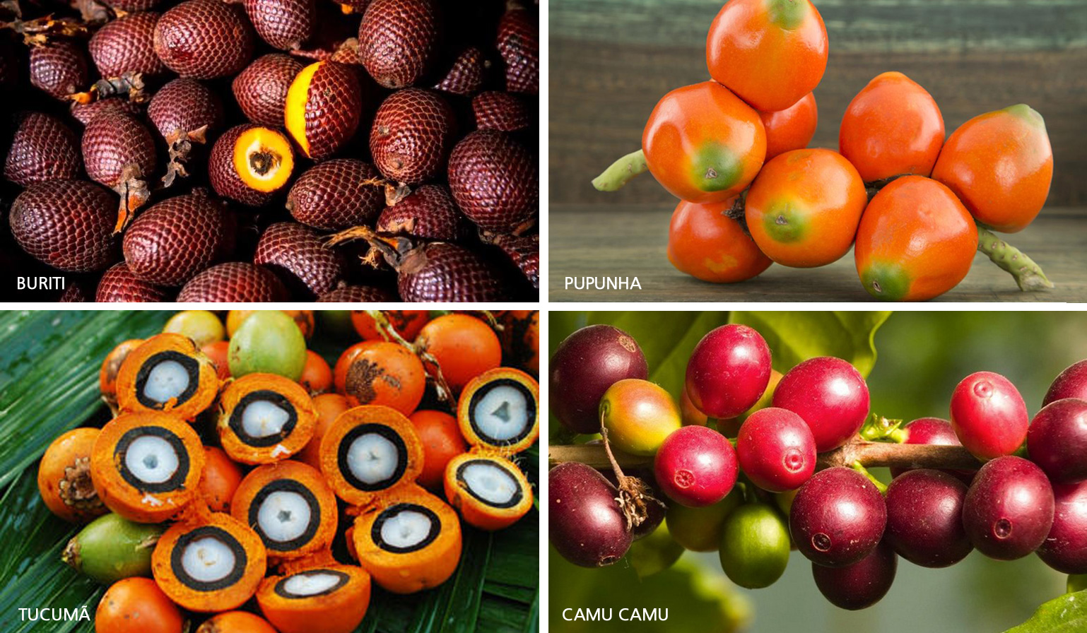
Buriti, camu camu, purple cará, pupunha e tucumã are some of the regional products consumed in the Amazon. Besides being easily found in fairs and markets of Manaus, they are rich in nutrients.
The typical dishes that stand out for their regionality and ecentricity are:
Acai berry | Tacaca | Duck in Tucupi | Jambu | Tambaqui | Pirarucu | Tucumã | Fried Banana | Tapioca | Guarana | Cupuacu


